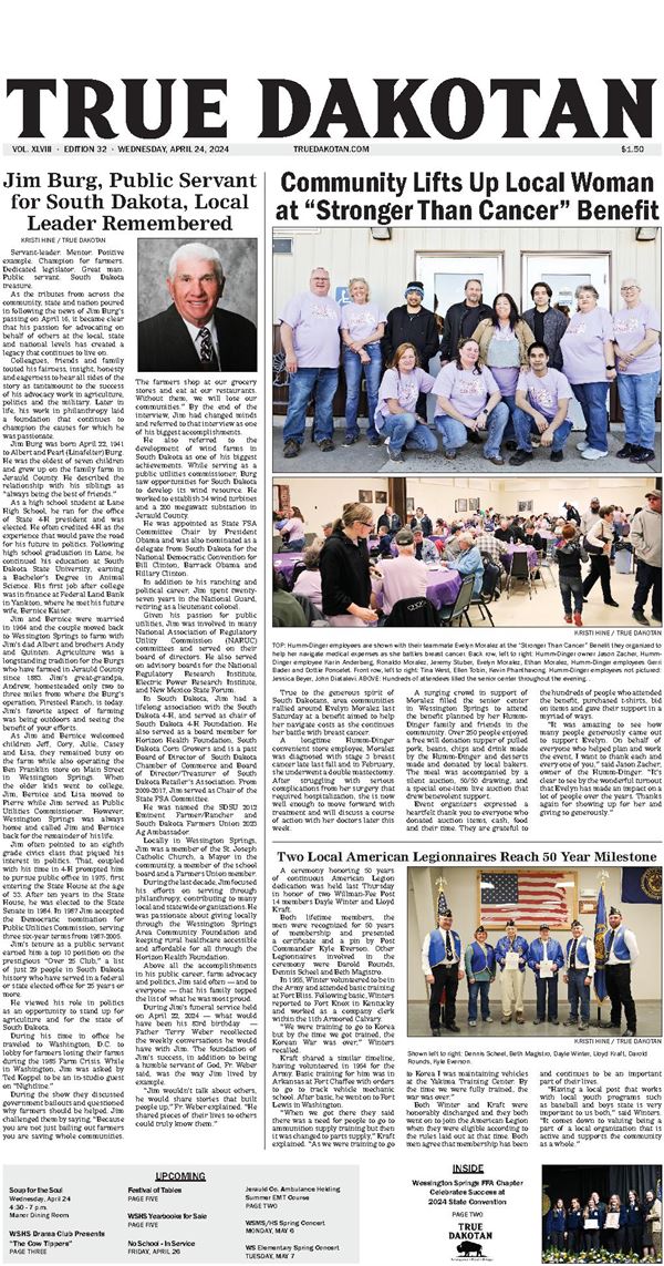

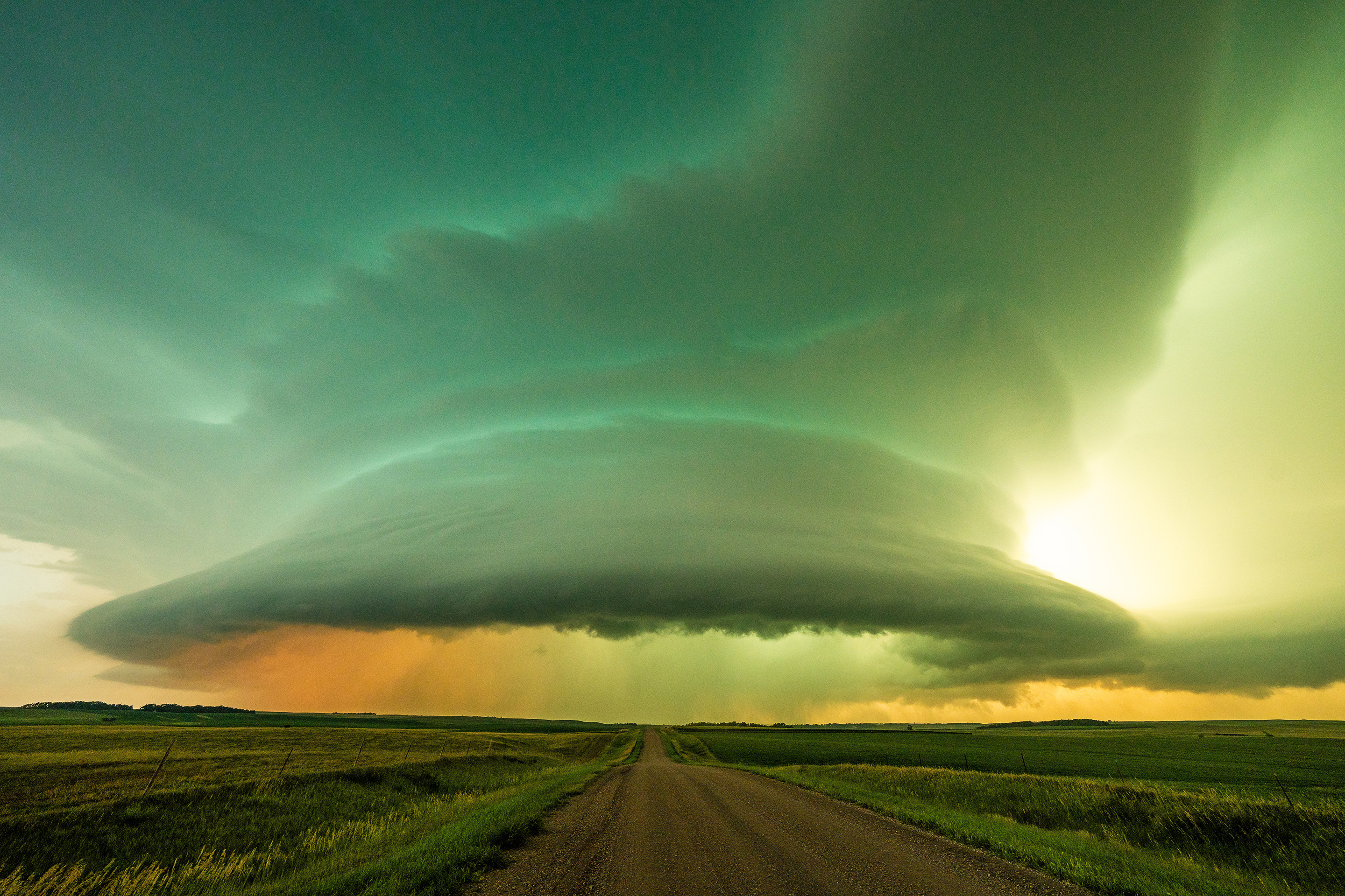
As the tornado siren wailed and residents of Wessington Springs took cover on Tuesday, July 25, storm chaser Jakob McMillin traversed gravel roads across Hand and Jerauld County in hopes of capturing images, video and data of the severe storm system making its way toward the City at the Foothills.
In his third year of storm chasing, McMillin drives a Subaru Outback outfitted with a GoPro camera that moves between the front exterior of his vehicle or mounted to the dash, along with two DSLR cameras.
“My Sony A7-R4 is my main camera for every chase with my super-wide angle 12 mm lens. That’s what I shot this system with — which was huge and I was really close,” he said of the storm cell he photographed north of Wessington Springs. “I knew a couple of days in advance that something was going to set up in both South Dakota and Nebraska but I’m glad I chose South Dakota — I even ended up missing a few Nebraska tornadoes for this trip.”
After studying satellite data and tuning in to what the weather stations were reporting, his initial trajectory took him straight toward Highmore until a shift in weather veered his course to the southeast.
“I was 10 miles northwest of Wessington Springs, shooting my camera directly east at the rotating wall cloud (shown on this page). I shot the image at 8:55 p.m. and high tailed it out of there because it was moving at me, and fast,” he said. “I couldn’t see a funnel at that point but after I sent the photo and shooting location to the National Weather Service, I was informed that tornado damage was reported at that spot. I try to report as often as I can because it helps the weather service, first responders and the overall safety of people in areas that experience this type of severe weather. Thankfully that storm was very well warned.”
Early warning is a tried and true practice for Jerauld County Sheriff’s Office, who had deputies storm spotting before the storm warning was issued that night.
“I knew there were chances of storms, so I was watching radar and we had two deputies watching it from Hand as it came into Jerauld County,” said Jerauld County Sheriff Jason Weber, who was off duty last Tuesday evening. “At first we thought it would miss Jerauld to the north. Then the tornado warning popped up in southeastern Hand at 8:38 p.m.”
At that point, Weber, along with off duty Deputy Mike Krueger sprung into action to assist Deputies Paul Sheldon and Dawn Lake with storm watching, surrounding the system at four points.
On Weber’s way to town, he called the National Weather Service (NWS) and they then informed him there was rotation in that system. Continuing on the phone with the NWS meteorologist, he had “eyes in the sky” when it came to the location of the rotation, where the storm was headed and the projection of what the storm was going to do.
“I could not see rotation from my position, but the warning and the intel from the National Weather Service helped us make an informed decision,” Weber explained. “The reason why we had zero fatalities and minimal injuries in the 2014 tornado was because of our early warning system. The decisions we made saved lives. So when this happens you think, ‘what did we do before that was so useful?’ It was undoubtedly the early warning. If there’s rotation and it’s headed toward town, we are hitting the button.”
Through dispatch, tornado sirens were deployed shortly after 9 p.m. Weber said that Alpena and Lane both also have warning systems in place: the Town of Lane’s siren sounds every time the Springs siren sounds while Alpena has its own separate system and storm sirens in all communities are tested every spring.
“When I went through town to head toward the storm, there were kids out playing and people outside all over. You can’t wait until the storm gets right to town to warn people,” he explained, also pointing out that Alpena and Wessington Springs Fire Departments were out storm spotting while Jerauld County Ambulance was also alerted and ready to respond.
“The response from the first responder agencies was top notch. You take all these different entities, put them together and we all work together seamlessly,” Weber said.
The storm brought 70 mph wind, 1.3 inches of precipitation and minimal hail, although the meteorologist at NWS said that particular storm was capable of producing hail up to two inches.
Another unique feature of the storm, according to McMillin, was the color of not only the wall cloud but also the blue and pink lightning in the system.
“You don’t typically get this kind of color, it’s pretty rare to see that,” he said. “Storms are very different and none behave the same way. Technically every storm you experience is a once in a lifetime event.”
McMillin’s photographs and video can be found online at mcmillinphoto.com, on Twitter @jakobwx and on Instagram at jakobstorms.